HURRICANE MELISSA MEAN BUSINESS: JAMAICA IN THE CROSSHAIRS
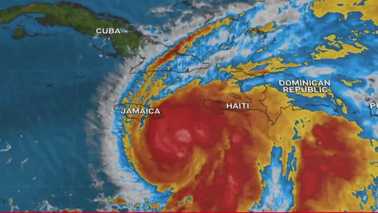
Hurricane Melissa has revved up into a major, dangerously slow mover in the Caribbean, exactly the kind of storm that wrings itself out over mountains and floodplains.
Official bulletins from the U.S. National Hurricane Center warn of life-threatening flooding, landslides, and storm surge, especially for Jamaica and southern Hispaniola. Airports are shuttering, shelters are open, and the rain totals being discussed are the kind that redraw riverbanks.
“Melissa isn’t just passing — she’s settling in to flood your postcode.”
Why Jamaica’s Risk Is Uniquely High
Jamaica’s mountain spine turbocharges rainfall when slow storms like Melissa crawl by. Meteorologists expect double-digit inches of rain with localized higher totals, the kind that historically triggers landslides, flash floods, and long power outages.
Authorities have activated over 650 shelters, and storm surge could push 10–13 feet into vulnerable south-coast areas. That deadly combo — ocean push plus inland torrents — is what makes Jamaica’s position so precarious.
“When the rain won’t move, neither can the people.”
Hurricane Melissa, The Slow-Storm Problem
Melissa isn’t in a hurry. Forecasters have underlined how its near-stalling motion drastically amplifies flood risk: rain bands park themselves, hillsides saturate, and the disaster footprint widens hour by hour.
Recent research shows slower tropical cyclones tend to cause far higher rainfall and flooding, a trend already seen in storms like Harvey.
Track & Timing — The 24-Hour Window
As of this morning, Jamaica is under a hurricane warning. Parts of southern Haiti and eastern Cuba are under hurricane watches. The forecast shows a powerful hurricane hovering dangerously near Jamaica within the next 24–48 hours.
Even before the eye arrives, outer rain bands are expected to dump torrential rain, trigger flash floods, and produce wind gusts over 100 mph in some coastal zones.
Mitigation: What Actually Reduces Risk
1. Move early, vertically, and inland.
If you’re near rivers or hillsides, go now — not later.
2. Think like a landslide.
Avoid sleeping downhill of steep slopes; cracking soil and tilting trees are red flags.
3. Assume water and power are gone for days.
Fill containers, charge devices, and check generators for safety.
4. Secure roofs and projectiles.
Zinc sheets, loose items, and doors should all be tied down.
5. Respect storm surge.
Coastal communities — memorize your evacuation routes now.
Jamaica’s government has improved resilience since Hurricane Beryl (2024) with stronger drainage and shelter programs, but as TriniLulz’s Disaster Desk notes — preparation only works if people act on it.
(For our previous coverage on climate change related Caribbean disaster readiness, read Sargassum Seaweed Takeover)
What’s at Stake: The Economic Toll
Melissa could easily become the costliest Caribbean storm of the year.
Early modeling suggests potential losses for Jamaica could exceed US$12 billion, depending on the track and how long the system lingers overhead.
Historical benchmarks tell the story:
- Hurricane Gilbert (1988): billions in losses, months of blackout.
- Hurricane Ivan (2004): tens of billions of Jamaican dollars in damage.
The Caribbean Development Bank and World Bank warn that a single major storm can wipe out years of GDP growth. If Melissa stalls, tourism, agriculture, and transport networks across the region will all take hits.
“When the wind stops, the bills start.”
After the Storm: Rebuilding Reality
Recovery priorities will mirror the usual Caribbean checklist — clear roads, restore power, and reconnect hospitals first. Economists emphasize direct cash transfers to affected families instead of red-tape-heavy donations.
The Caribbean’s leaders are expected to renew calls for debt pauses and climate disaster financing, as small island economies can’t keep rebuilding from scratch every hurricane season.
For up-to-date forecasts and safety information, visit the National Hurricane Center.